Protonmail just deleted this message instead of sending it. I assemble each message individually which takes some time so I’m sorry but I am just going to forward this to you and I hope you can see the images.
Energy weapon targeting La Palma could trigger a tsunami and kill millions
We know these weapons exist. We know they have been used before. We know that there is an ongoing, intentional genocide aimed at the Christian countries. Already, up to 5 million people may have been murdered by the deathvaxx with many more millions yet to die. Genocide is genocide and the oligarchs are set on taking out as many people as they possibly can by any means available. Their stated aim is to reduce the world’s population to 500 million people. In that, they will not succeed, but …
It looks like La Palma is being targeted by an energy weapon designed to deliver 500 km3 of rock into the Atlantic, which could wipe out America’s east coast, as well as the coasts of West Africa, Spain, France, Portugal, Ireland, Britain and Scandinavia.
Hal Turner Radio Show: EVIDENCE THAT LA PALMA ERUPTION & EARTHQUAKES ARE ARTIFICIAL ATTACK!: https://halturnerradioshow.com/index.php/en/news-page/world/bulletin-evidence-that-lapalma-earthquakes-are-artificial-attack
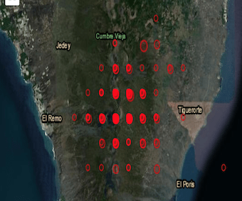
European-Mediterranean Seismological Centre (EMSC) map: https://www.emsc-csem.org/Earthquake/Map/gmap.php (zoom in on La Palma to see the regular, artificial grid pattern) It would be a good idea for them to explain the regularity of these patterns, which are not replicated elsewhere on their maps, where earthquake patterns are irregular and random.
La Palma Mega Tsunami.mov. This is based on the Ward and Day scenario of 500 km3 of rock falling into the Atlantic: https://www.youtube.com/watch?v=Zb4T8a1K5tw (and see article at https://electroverse.net/intensifying-seismic-crisis-at-la-palma-volcano-mega-tsunami-potential/)
(Heights in metres)
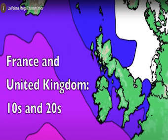
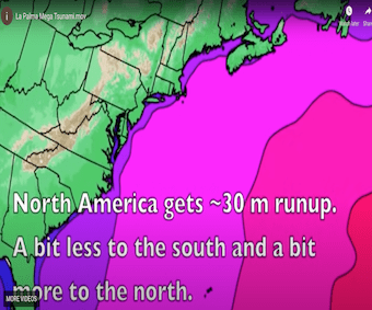
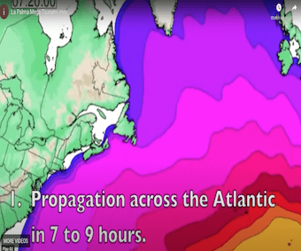
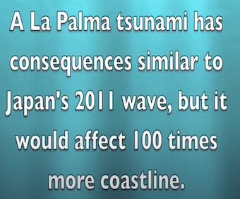
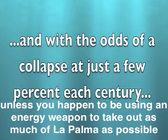
La Palma landslide tsunami: calibrated wave source and assessment of impact on French territories, 10 Nov 2020: https://nhess.copernicus.org/articles/20/3019/2020/ – based on 80 km3 scenario. HOWEVER:
“On the other hand, the extreme scenario of 450 km3 as studied in Ward and Day (2001), Løvholt et al. (2008), Abadie et al. (2012), and Tehranirad et al. (2015) has not been computed in the present. This extreme scenario, however, remains possible as evidenced by the volumes of the deep water deposits identified in Masson et al. (2002) around this archipelago. Nevertheless, we focused on the 80 km3 as it is consistent with the size of the deposits identified at the toe of the volcano, possibly corresponding to its last massive flank collapse (about 300 000 years ago).
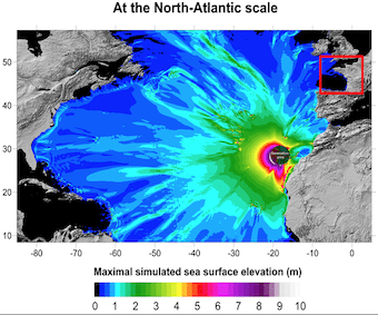
La Palma Tsunami Map / Tsunami Map For La County Details Hazard Levels Nbc Los Angeles : The collapse of the western flank of the cumbre vieja: https://cirostryker.blogspot.com/2021/09/la-palma-tsunami-map-tsunami-map-for-la.html
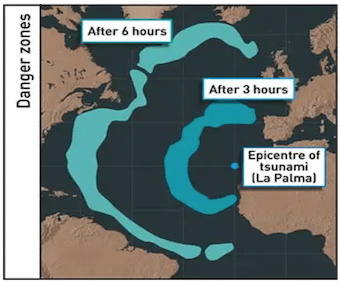
Before It’s News video report: https://beforeitsnews.com/terrorism/2021/10/hal-turner-warns-la-palma-island-volcano-under-attack-with-energy-weapons-to-cause-mega-tsunami-earthquakes-repeated-over-and-over-at-exact-same-locations-2462710.html
La Palma volcano eruption: Summary news October 11: https://en.as.com/en/2021/10/11/latest_news/1633945503_054085.html
Cumbre Vieja showing few signs of slowing down
The swifter flow of lava from the Cumbre Vieja eruption means that the affected area has now grown to 595 hectares, according to local reports. Experts are unsure how long the eruption may last, but estimate anywhere between one and two months, or perhaps even longer.
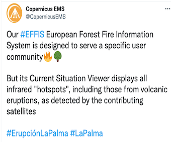
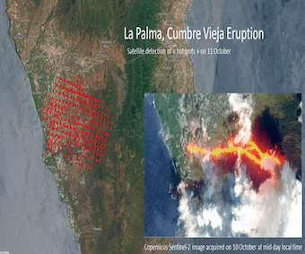
European Forest Fire Information Service
This map also shows a regular grid pattern. Is this just the result of the way the data is collected by satellite or does it signify yet another genocidal conspiracy? Some of these taxpayer-funded “authorities” that we all trust so much (not!) should explain this:

WORLD EXCLUSIVE: The FLOE Show 10: Hydra Vulgaris is an operating system in a human clone experiment
to breed new hubrid race
- REKO rings, farm shares & farmer bazaar – “Solutions Watch” with James Corbett, 12.10.21
- (US) states & communities can fight back against tyranny & lawlessness, 16.9.21
- Human Rights Unity – Philippe Argillier
- Animap business directory for the unvaccinated: Austria link; France link; Switzerland (francais, Deutsch Italiano)
- Freedom Travel Alliance
- International Solidarity Of Free Information & Arts
- Barterfly Foundation: Let´s change the future
- L’Alliance Humaine – medical and educational advice (home-schooling) – seeking translators & others
- National Vaccine Information Center (US)
- New Civil Liberties Alliance
- Reignite Democracy Australia
- Viruswaarheid – Virus Truth – Netherlands – Willem Engel
- The White Rose (UK): defence freedom, defend humanity
- Hundreds of electric cars have been left to rust in a French field for three years after a failed experiment
- Here is the hidden $150 trillion agenda behind the “crusade” against climate change, 13.10.21
- Emergency responders still can’t safely and quickly extinguish electric vehicle fires, 3.10.21
- Dutch greenhouses go dark as energy crisis worsens; food inflation fears mount for Europe, 3.10.21
- Will the green new deal cause food shortages? 13.1.21
- Electric cars: Pollution warning over car tyre and brake dust, 11.7.19
- AUS: hospitals directed to replace ‘unborn baby’ terminology with ‘parasite’ to avoid abortion offence, 18.10.21
- 5 MEPs express dissent over compulsory Digital Vaxxine Certificates – where are the others?? 22.10.21
- Florida Surgeon General & DeSantis destroy the case for masking kids in under 3 minutes , 21.10.21
- One app to rule them all – time to get rid of your smart phone, 14.12.21
- Poisoned tap water in the UK, 8.10.21
- Eating babies? Georgia school has teens ‘solve’ hunger with cannibalism, 14.10.21
- Vaccine mandate threatens Massachusetts Dept. of Corrections, about to lose 50% of its prison guards, 15.10.21
- WHO issues clinical case definition of long Covid – how about getting rid of the cell phone that is giving you “Covid”?? 13/10.21
- As the energy crisis explodes, they are warning that heating bills will be extremely painful this winter, 15.10.21
- Plastic bag put over teen Covid patient’s head at TX hospital, 12.10.21
- US billionaires got 62% richer during pandemic: now up $1.8 trillion, 30.10.21
- USA: San Diego citizen blasts county board for crimes against humanity, 20.10.21
- Dr. Luis Martinez: the spike protein does not exist, 2.7.21
- How health and medicine was highjacked and turned into selling sickness and poison for profit, 7.6.20
- An Irish soldier speaks out, 27.9.21
- Healing without drugs: Western culture has lost its way, 13.19.21
- The Vaccine Death Report Zelenko and Sorensen, October 2021
- 26,041 deaths 2,448,362 injuries following Covid shots in European Union’s database as Slovenia suspends J&J shot after death of 20-year-old student, 25.9.21
- Australia records 10X more deaths following Covid-19 shots than recorded deaths following all Vvaxxines for past 20 years, 25.9.21
- UK medicine regulator confirms there have been four times as many deaths due to the Covid-19 vaxxines in 8 months than deaths due to all other vaxxines combined in 20 years, 25.9.21
- Does the SARS-Cov-2 virus exist or is this state-sponsored genocide?
- REST IN PEACE
- Pine needle and chaga tea: how to make healthy forest tea
- Dr Zandre Botha protocol: Treatment for vaccine injury
- The Spanish Flu epidemic of 1918 – Is history repeating itself? (Bicarbonate of soda – very touching testimony from centenarian), 17.9.21
Spain: consitutional court orders government to return fines imposed during first lockdown, 24.10.21
- Workers at Los Alamos nuclear lab in New Mexico sue over vaccine mandate, 14.10.21
- Federal judge in Texas halts United Airlines’ enforcement of employee vaxxine mandate, 13.10.21
- Italian court sides with nurse wrongly suspended for refusing COVID-19 jab, 29.9.21
- German court rules YouTube’s censorship of Covid measures criticism was “unlawful”, 13.10.21
- Military members with natural immunity file class action lawsuit to block mandates, 3.9.21
- Hydra vulgaris: researchers figure out how to build an artificial brain from the bottom up, 29.6.21
- Water quality: is bottled water pure? part 2, 17.10.21
- One app to rule them all – time to get rid of your smart phone, 14.12.21
- Samsung wants to put the human brain on a computer chip, 5.10.21
- Building brains for the metaverse – executive function, augmented cognition, & soul theft by Alison McDowell, 28.9.21
- Samsung says 6G will bring ‘digital twins’, 6.10.21
- Indestructible hydra in vaxxines creates neural network, 4.10.21
- 5,427% increase in deaths following Covid shots revealed by PhD researchers analysis of VAERS data , 23.10.21
- The Covid testimony of Dr Peter McCullough – Part 2: The vaccines are killing people, 19.10.21
- The victims of the deathvax whom the mainstream media will never talk about, 23.10.21
- Hydra Vulgaris is an operating system in a human clone experiment to breed new hubrid race, 21.10.21
- Shocking: Dr. Carrie Madej releases first look at Pfizer vial contents, 20.10.21
- Vaxxed have much higher incidence of viral loads in noses: 82% vs 29% in unvaxxed, 21.10.21
- Fully vaxxenated are Covid ‘super-spreaders,’ says inventor of mRNA technology, 12.10.21
- Proof: Luciferase found in Covid vaxxine company patent, satanic big pharma company? 17.10.21
- What’s the educational level with the most vaccine hesitancy? Ph.D. level! 16.10.21
- Taiwan records more Covid vaxxine deaths than Covid-19 virus deaths, 16.10.21
- Video: genocide of seniors continues as FDA & CDC recommend 3rd booster shot – thousands already dead, 24.9.21
- Video: Post Covid-19 injections: the dead don’t speak, but those with crippling injuries issue warnings, 4.10.21
- Deaths reported to VAERS by year, 16.10.21
- EudraVigilance: 27,247 dead, 2,563,768 injuries as at 9.10.21
If you no longer wish to receive information about the Stop 5G campaign from this source,just click “Reply” and say so. Thanks!Si vous ne souhaitez plus recevoir d’informations de cette source sur la campagne Stop 5G,cliquez simplement sur “Répondre” et me le dire. Merci!Wenn Sie keine Informationen mehr über die Stop 5G Kampagnevon dieser Quelle erhalten möchten,klicken Sie einfach auf “Antworten” und sagen es. Danke!